How early were your ancestors in North Carolina?
If they were here prior to the War of Independence, then it might be worthwhile to check the Moseley Map for their names, or at least their surnames.
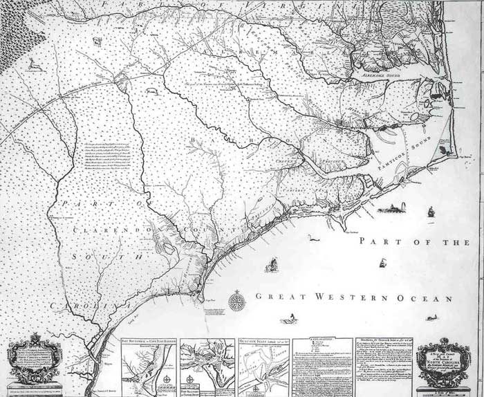
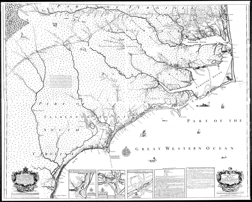
The Moseley Map was created in 1733 by Edward Moseley (1682-1749), who was Surveyor General of North Carolina from 1710 — just after the famous John Lawson — and was marketed at the time as “A New and Correct Map of the Province of North Carolina.”
East Carolina University holds the only known original print of the Moseley Map in their incredible archives. Once owned by Mr. Hugh Williamson Collins of Edenton (1863), Moseley’s is said to be “the first map of NC to be based mainly on actual exploration or surveys, rather than reports,” according to the ECU Special Collections website.
The map’s description reads:
A New and Correct Map of the Province of North Carolina by Edward Moseley, late surveyor general of the said province ([London]: Sold at the Three Crowns, 1733). Shows settlements, inhabitants, soil conditions, rivers, and principal products, with insets showing Port Brunswick or Cape Fear Harbour, Port Beaufort or Topsail Inlet, Ocacock [Ocracoke] Inlet, Explanation, and Directions for Ocacock [Ocracoke] Inlet.
Indexing the Moseley Map
While the Moseley Map is not exhaustive in naming every family that lived in North Carolina at the time, many prominent land-owners were named. Clusters of families and Indian tribes were also named, such as the entry for “Palatines” in the section South of Trent River up to New Bern, referring to families that settled the New Bern area led by Baron Christoph von Graffenreid or “Tuskeruro” named on the Roanoke River referring to the Tuscarora Indian tribe.
In February 1991, Susan M. Trimble of the North Carolina Colonial Records Project compiled a full index to the map, complete with grid locations for the names indexed, and it was published by the North Carolina Division of Archives and History, Historical Publications Section.
It can be viewed online or downloaded as a PDF (right-click PDF and “Save link as…” to download) at the Internet Archive.
The list below is a wonderful condensed index that I had saved in my archived files on my computer, although, unfortunately, I’m unsure of its attribution, so if you know who originally published the list below, please leave a comment in the box at the bottom of this article.
Here’s an important tip: Do NOT use “Ctrl-F” to try to find your ancestral surnames in this list. Instead, just read the list, as many spellings of surnames are different than the conventionally used spellings.
[A] ROANOKE RIVER-headwaters to the south shore of Albemarle Sound:
1-Davis[W], Young[J], Spann(Spann’s Mill), Allen, Falls, Reeves, Mellikan[J], Little[W], Mackinne[B], Bryant[T], Ooneroy, Refootketh, Tuskeruro, Cheeweo, Quitzna, Castellan[J], Speller, Charlton[W], Meazle, Blount, Beasly
Note: At the headwaters [here called the Fitzwilliam River] on the NC/VA line-20,000 acres to Col. William Byrd of Virginia.
2-South shore of Albemarle Sound: Whitemarsh, Pollock[C], Buncomb[J], Frilie, Lee[S], Lee, Cooper
[B] ALBEMARLE COUNTY – BERTIE PRECINCT
1-Along the Meherrin and Chowan Rivers to Albemarle Sound: Allen [E], Pitman, Kirchin, Anderson, Jackson, Gee, Bryan, Nansemond, Dew, Powers, Williams [A], Bond [J], Jones, Cotton [J], Hill [B], Baker, Barfields, Baker [H], Williams, Hains, Forster [R], Maule [W], Winn [G], Boone, Bryan [F], Hill [J], Pollack [T], Lovick [J], Pollock [G]
2-Albemarle Sound [west shore] between Chowan and Roanoke Rivers: Duckinfield [N], laccuck, Lockart [J], Henderson [D], West [R]
[C] CHOWAN PRECINCT – East side of Chowan River:
Meherrin, Baker[H], Alston [J], Bennett, Parker, Blanthard, Spivy, Hill, Perry, Hunter, Lee, Pendal, Speight, Barns
[D] EDENTON AREA – between Chowan and Yaupin Rivers [north shore of Albemarle Sound]:
Heath, Altin, Luten, Paget, Gale [E], Jones [H], Gale [C], Vaile [J], Moseley [E], Jones [F], Beabury, Beasly, Blount [J], Vaile, Porter [E], Pearce [T], Ward [J].
[E] PERQUIMANS PRECINCT – between Yaupin and Pequimans Rivers:
Sturgeons, Durant, Norcomb, Harvey [T], Denman [C], Skinner [R], Sander, Pettiver, Phelps, Speight
[F] PEQUIMANS PRECINCT – between Pequimans and Little Rivers:
Clare, Jessup[J], Sutton[C], Nixon, Forster [F], Whidby[R], Bateman, Sanderton, Swann [S], Parish, Bartlet, Hatch[A], Sanderton[A], Catchmaid.
[G] PASQUOTANK PRECINCT – between Little and Pasquotank Rivers:
Hall, Nixon, Lowry, Evans, Salton, Boyd, Baily, Swann, Pritchard, Hague, Palin [J], Pendleton, Davis, Mabson [F], Reed [W]
[H] PASQUOTANK PRECINCT – between Pasquotank and North Rivers:
Spence, Burkham [G] (at Joy’s Fork), Jones [G], Janson, Mann, Jones, Hawkins
[J] CURRITUCK PRECINCT – between North River and Currituck Sound:
Wilkins, Balance, Hodges [M], Swann [T], Etheridg, Lowther, Williams, Tulle, Swann [W], Dukes [M], Sanderson, Williamson, Norton, Gibby.
[K] Eastern shore between Albemarle & Pamticoe Sounds:
Moyes Creek, Spencers Creek, Mann [L]
[L] BEAUFORT PRECINCT:
1-North Shore-Pamticoe River: Lillington[A], Adams, Pilkington, Snoad, Boyd
2-Bath Town: Kenyon, Odeon, Aldeson[S], Martin, Worsly [J], Salter [E], Riouset, Adams, Jones, Ottiwell
3-East of Bath Town to the Sound: Jewell, maule [P], Perkins, Barrow, Adams [P], Dowry, Jones [P], Woodstock, Slade, Jasper, Mattamuskeet
[M] South shore – Pamticoe River:
Tuskeruro Indians, Mallard Creek, Chicod Creek, Salter [E], Kingman, Worsly, Blount, Reading, Coldom, Hill, Slade, Slade [B], Crofton, Maule [P], Locker, Peyton [R], Trip [J], Porter, Nevil, Turner [R], Leigh, Jones, Campaign [R]
[N] North shore – Neus River:
1-on Smyth’s Creek – Reels, Gatlin
2-Craven Precinct – Johnson, Beard’s Creek, Frank[M], Wilkinson’s Point, Dawson’s Creek
[P] South shore – Neus River:
1-Craven Precinct-New Bern – Fonville, Handy
2-South of Trent River up to New Bern – Jones [Frederick]-7375 acres, Wilson [W], Hancock, Palatines, Glover [C], Hatch [A], Handcock [H]
[Q] Hatteras Island: Gibbs, Neal, Hatteras Indians
[R] Beaufort Town Area:
1-Near Beaufort Town – Taylor [N], Shakelford, Shaw, Rustul [R]
2-Across North River, east – Wicker, Burnet
3-On Core Banks Sound – Nelson, Willis
[S] CARTERET PRECINCT:
1-Cape Carteret – Lees
2-Queens Creek – Green
[T] ONSLOW PRECINCT:
1-NE shore New River[Jacksonville] – Howard, Lillington[H]
2-SW shore New River – Ennitch
3-Along the coast between New and Cape Fear Rivers [Jacksonville to Wilmington] – Johnson, Beasly, Frederick, Alexander, Vaile[J], Nixon, Hauser, Swann[S], Staples, Hudson, Watts, Perry,
Porter, Howe
4-East bank – NE Branch Cape Fear River – Harrison[C], Watts, Mardsen, Carter
And now, for the map (clicking on the map will bring up a much larger version from East Carolina University in a new window).—
67 comments
Lisa Rae Lowrey Gonzalez
Still looking for information on the Norcumb family. Does anyone have information on this family with this spelling? Thank you!
[E] PERQUIMANS PRECINCT – between Yaupin and Pequimans Rivers:
Sturgeons, Durant, Norcomb, Harvey [T], Denman [C], Skinner [R], Sander, Pettiver, Phelps, Speight
Ellen Dew Ruey
I was excited to learn about this map and to find my Dew ancestor’s land shown on it. I saw other names on the map in my family tree that will take more research -to verify they lived in the area shown – Bryant, Bryan, Beasley, Spence, and Taylor. Thank you for the information about the map and the links.
SANDRA SMITH
TRYING TO RESEARCH FAMILIES OF WILLIAM FOLKS, SR. -1735 CRAVEN COUNTY AND MARGARET STONE – 1740 CRAVEN COUNTY AND THEY ALSO
MARRIED IN 1757 CRAVEN COUNTY NC. I HAVE HIT A BRICK WALL ANY ADVICE OR HELP WILL BE APPRECIATED.
THANKS, SANDY SMITH
Lynda Crabill
I have a David Cooper in my genealogy line and they are in North Carolina. They marry and end up in South Carolina. Oprha Cooper married a Daniel Amos? Is this part of your line??
568832Daw
I do not get it. The Moseley Map does not include William Daw, son of Capt. Nicholas Daw, Hatter of Bath Town. William owned a lot of land before his death in 1745. Was there a certain threshold of land that had to be owned to get on the map in the first place? This is confusing because the Daw family had been in Beaufort County and Craven before 1700.
doris doristhompson
Thompson
Lisa Smith
My Adams family lived out in Piney Creek NC and some still live there. I will need to research more to see if Jesse is related. Thanks for the info.
Susan Hurst
Seeking information on Hurst and Kingham families.
Ann Wrenn
When researching my “Capt. Edward Moseley 1718-1808” upon a study of the Ludwig Bucholtz Map of 1859
In April 1769 it is recorded that Henry Clay sells 1355 acres in Charlotte County to Edward on the west side of Blewstone Creek, an area “bounded by patent line and the head of Rasberry Branch. All Appurtenances.”
The “Moseley F&B” name is written on a 1859 Ludwig Bucholtz map of Charlotte County right at the confluence of Staunton River and Buffalo Creek.
He was justice of Charlotte County, vestryman of Cornwall Parish, 1765, and captain of militia, 1778.
He is listed as Edward Moseley, Captain on the CHARLOTTE COUNTY MILITIA AND OTHER SOLDIERS BEGINNING IN 1767.
It is noted that William Bentley and Capt Moseley operated a Toll Bridge over Staunton in early 1800s.
Capt Moseley owned a home, once called Slate Hill that was located where Buffalo Creek flows into the Staunton River, six miles northwest of area where Amelia, Chesterfield, and Powhatan counties intersect.
Capt. Edward Moseley died September 3, 1808 in Charlotte County and is buried in his family cemetery near Buffalo Creek.
More Later, Ann
[email protected]
Lisa
I was excited to see that the Norcumb name, and not Norcom, was mentioned on the Mosely Map here:
[E] PERQUIMANS PRECINCT – between Yaupin and Pequimans Rivers:
Sturgeons, Durant, Norcomb, Harvey [T], Denman [C], Skinner [R], Sander, Pettiver, Phelps, Speight
The Norcumb family is a part of my family that has remained a mystery. I have been trying to find information on Mary A. Norcumb, my 3X Great Grandmother, that married Jacob Darden Windley in 1840, Washington, Beaufort, North Carolina. They had a son, Joseph Norcumb Windley. Does anyone have any information on the Norcumb family or know where I can find more information? I have been striking out everywhere I have looked. Thank you!
Dave wells
I am looking for any information on the Jacob Wells immigrating to the New Bern area in 1710.
Ron A Young
I am looking for information about the George Young family who left Virginia in the late 1700’s, stayed in North Carolina temporarily, then proceeded on to Oglethorpe County, Georgia. I am particularly interested in their stay in North Carolina.
Sheri Green
I am surprised that Russell isn’t on the list. Samuel Russell and his ship The Scorpion came across from Scotland and traveled up what is now thw Cape Fear River…and created the town Russellborough…will someone plz see why this important family was left off the map…thanks.
Sara Whitford
This map was made in 1733 and this site tends to focus more on the areas around the Neuse, Pamlico, and Chowan Rivers. I’m not familiar with the history about this and I’ve tried to look it up, but everything I’m seeing about Russellborough says it was founded by Capt. John Russell. I also haven’t seen anything related to The Scorpion and most Scottish settlements with which I’m familiar came decades later than the settling of the Neuse / Pamlico / Chowan River regions. If you have a link about it, I’d love to see it. I’m always up for learning something new. Thank you!
Kenneth Reason
I am Ken Reason : My Mothers side Patterson is from Scotland then Ireland and all many all over the globe. My Fathers side is Reason shown thru northern and eastern North Carolina Dating back to the 1700’s . Grand mothers family being Biggs. I’ve got close to 3,000 family members but accurate to early 1800’s. If i can assist let me I am in Va. Beach area. But if you have any history to give I would in deeply appreciate any help
Anne Chitty Lang
I am looking for any Litchfields in the mid to late 1700s. Possibly Tyrell, Currituck, Hyde or surrounding counties.
Linda
I am a descendant of Jesse Adams who settled in Lewis Fork on the Yadkin River. In trying to find out where he came from a tax record states that he was a son of William Adams Sr. and lived on Williams plantation for a while. I found an Adams plantation on the map in the Beaufort area. That may be my link, especially if he Adams family moved further west by the 1750’s. I’m glad I found this.
Lisa Smith
My Adams family lived out in Piney Creek NC and some still live there. I will need to research more to see if Jesse is related. Thanks for the info.
Patricia leslie grEen
Hi, I am a patricia Green, daughter of miles Leslie green., Samuel Jacob Green was my great grandfather in my fathers side. I believe my family lived in Rutherford county and farms cotton, tobacco and rised cows there. There was a William Green in my ancestory. We fought in Revolutionary war and the civil war. We were in North Carolina very early
Sheri Green
I am Sheri Green…most Green lines actually settled in Western NC but due to work ie Farming many moved to the coast.
Marilyn Morrison
My great great great grand fathers were Hatteras Indian. I would like to know more about the Hatteras Indian reservation and it’s location. Hopefully, it will help to find his grave.
Marilyn Berry Morrison
TJ Dossett
Hi. Just saw your post. My husband’s family was in eastern NC & spoke of Eno /Tuscarora/Iroquois nation relatives going back.
When doing DNA, he was surprised to only get mostly England/Northwest Europe with some Scots and Irish.
I’m curious if with your Hatteras Indian heritage, have you found yourself or any relative who showed some sort of Native American heritage? Years ago I read that those who were very early immigrants to the east coast and married NA show up as Eng/NW Europe because there is not enough identifiable subgroup that you do find with NE Indians/SW Indians/etc.
So again, did you ever find something DNA wise that confirmed the hatteras indian heritage? While people claim that many made this up in the up, I find that hard to believe because people in the past would be more likely to hide any “strange” heritage than they would be to proclaim it.
This all probably sounds terribly politically incorrect but honestly asking from a ancestral viewpoint. Hubby thinks his family lied to him about various stories & I’ve tried to convince him that I seriously doubt they were fabricating everything. In my case, I did have definitive DNA confirmation of heritage that was never discussed in my family when I was young. Struck me as odd at the time but later as I did research it made more sense to me.
Thanks in advance for anything you have discovered.
kenneth burns
i am historical demographer living in Columbisa; I have some census training. If I can collaborate on your search–such as looking at the pre-1790 south carolina censuse, let me know
richard Kenneth Burns
[email protected]
Columbia S> (actually in Richland county near St ANdrews road.
KENNETH
Sara Whitford
Hi Kenneth! I see you left this comment months ago, but for some reason I’m just now seeing it. Thank you for your offer to help with the South Carolina census, however this site is focused on eastern North Carolina. I’m glad you left your comment, though, because someone with South Carolina roots may see it and would love to take you up on your offer!
Ann Mc
Does anyone know if descendants of Edward Moseley ended up in South Carolina? I’m descended from Gidaon Moseley of Aiken SC.
Jack Paramoew
Looking for early settlers Parramores…decendents of John Parramore who came to the eastern shore of va in 1622
Any leads appreciated.
Jack Paramore
Frances Sawyer
Jack Paramoew: I have a PARRAMORE line going from Elizabeth Rolf (1681- ) Thomas Parramore (1681-1743) to Jessee through 2001. The line is not broken to Jeremo Hamren.
Sara Whitford
In our family, we don’t descend from any Paramores (that I know of), but I have come across them in my research in Pitt County, NC.
Tanya Wisler
My family lines in Pitt County are Atkinson (Bensboro Plantation), Rives, Bryan, Hill, Whitmel.
LARRY BARROW
do you mean the Samuel Willis of Willis Neck Craven County. Che had a great plantation off the Swift Creek of the Neuse River. His family cemetery bears many headstones of the Willis clan. they were here in the mid 1700s. they are my mother’s people and many Willis still live here today.
Susan Chiaverini
My family line comes from James, brother to Samuel. Is there any document that you know of that tells who the parents were of Samuel, James, Joseph and Thomas? Or one that tells where they lived before Craven County?
Thank you!
Sue C.
Julia Austin Paul
Looking for a Campbell that Campbell’s Creek off Goose Creek ITW across in Beaufort County is named for … deed Dated 1735 referenced “”old Campbell house & “Camels folley”.
Billie
If you’re still interested, I think these Campbells were my ancestors, Archibald Cammel/Campbell, son James, son Ransom (moved to Cumberland County).
Sara Whitford
Have you been able to trace back before Ransom Campbell? I’d be interested in knowing who his people were. All I have on Ransom Campbell can be found here: https://www.ancestry.com/family-tree/person/tree/3354391/person/292179659174/facts
Rita Daugherty
im looking for information on Leonard Hain, Haines, Hains family. Also Edward or Thomas Stockstill, Stogsdell, Stogdell. possible in Jersey settlement area Rowan co bout 1768.
Proud Family Genealogist
I think Sanderton should be Sanderson. Richard Sanderson is my 8X grandfather. He was the original owner of the Cupola House in Edenton.
Stuart Chaplain
Looking for Chaplain/Chaplins in the Currituck Co. area. When did they come to NC and from where.
Ingrid Hardison Thompson
I saw the name “Hardy” listed but not “Hardison”. My 8x grandfather was named Jasper Hardison. I did see the name Jasper, listed also. He died in May 1733 and did leave a will that is on file at the NC Archives, Raleigh. He was a planter in Jamesville, NC. He had a grist mill and sold lumber. His son, John Hardison was a delegate to the 2nd Continental Congress. He was issued several land grants. The family home was named “The Rose Plantation” and sat west of the Albermarle Sound. Why was he not found?
Barbara Lance Alldaffer
My Mom’s side comes from the Cooper’s of the south shore of Albermarle Sound and specifically the communities of Gum Neck, Frying Pan and Alligator in Tyrrell County. The earliest one I have found is David Cooper Sr born 1750 . Have not been able to trace them further back, would love to find out where they originated from.
Lynda Crabill
I have a David Cooper in my genealogy line and they are in North Carolina. They marry and end up in South Carolina. Oprha Cooper married a Daniel Amos? Is this part of your line??
Alyce C Matthews
My side of the family were from these same places. Names were Best and Sawyer and others. They traveled together to the lower part of Illinois. Have you been to NC? I went about 10 years ago and have pictures of Gum Neck and Frying Pan.
Jan King
The Fonville’s in New Bern Craven County are my ancestors
Martha Mallett
Who were the Palatine families referenced on the Moseley Map? Where? There are early land deeds for Bullens. Conrad Bullen emigrated early 1700’s from Palatine area of Germany and became naturalized citizen in Sept, 1763, Salisbury.
antony blackwell
These could be from the German region as you stated. However, there was a 1669 document that outlined the creation of ‘palatine” landgraves and casiques in the Carolina Colony when it was under the Lords Proprietor. A few of these were created as a colonial imitation of the British Peerage. The term palatine could also be in reference to people living on the lands of these landholders. If so, they paid “quit rents” to them, as to avoid being required to work on the landowner’s land and house. As tenant farmers, this rent freed them to work on their own plots and such.
Bonnie Leonard
Looking for last name Goley or Leonard.
Mona Williams
I have lots of Leonards in my ancestry!
Cheryl Williams
Did any of your Leonards come into Georgia?
carlene adkins
would the last names of mallican or millican be also milliken
Christine Weeks-Bates
I find it kind of interesting that Thomas Week(e)s was a keeper of the land titles early on, but his name doesn’t appear on the survey. Can anyone figure out why that would be? He lived on the Little River, and was on the Assembly and was Court Clerk for quite a few years. His name appears on the marriage licenses of many, and their Wills, along with land grants.
carole Willis Lang
I’m looking for the Robert Willis family, from Eastern part of the state,in the 1700’s
willis
Was he related to Samuel Willis circa 1700 ?
Dan
Looking for the parents of Andrew Ganus born 1822 and the parents of his wife Mary Eliza Chance, born 1828 Can’t go any further back than these two on my genealogy. Any help?
ronnie french
hello, seeking ellis, or french
Cynthia Long
Any longs or langs in there?
June Perry
Happy to see the Perry’s and Slades of our family listed. Note: the Perry’s married into Cumbo family also related to the Meherrin tribe. Thank you for this historic map!
Patty
Is there any Thomas Dixon or Dickson family living there in the early 1700’s. My Greatgrand father was suppose to be born there in 1774 his name was Henry. He moved to Kentucky .
William Privett
My great grandmother was Caroline Perry Privett. She is buried in Franklinton Community Cemetery. Perhaps we are distantly related.
Robin Weldon Hildebrand
I thought it was interesting that land records recorded that:
On 30 January 1720/1 he was called “Edward Bass of Norfolk County, Virginia, Parish of Elizabeth” when he purchased 100 acres adjacent to his brother John, near the head of Horsepool Swamp in Chowan Precinct, North Carolina [DB C-1:113].
But not on Moseley’s list?
WENDy Albright
My Great great grandmother was Caroline perry Privett . I am the great grand daughter of pattie privett Joyner. I am looking to fill in my family tree. Who was Caroline married to cuz?
tripp
i believe some of the tripps family moved down to anderson sc.
Mary Boston
The John Boston family lived in Onslow County on the NW Branch of the New River near the William Williams property in the 1760’s. They stayed in Onlsow County until 1785 when they left for GA. There was also a Hugh Boston, who could have been his father or brother in the same area.
Nathan Langley
Hi, do you have any info on the Williams that left and went to Georgia? Researching Isham Williams born 1776 (he said born SC in 1850 census). He died 1852 GA. He’s my 4G Grandfather. Thank you!
Sarah Rae Cape
Hi Nathan I can not help on th Williams line But I am curious about your Langley line.
Maryte Dyess
Baron Christopher DeGraffenreid is my direct ancestor.
antony blackwell
Most of my mother’s people were from Tidewater Virginia, and seemed to have skipped North Carolina and settled in South Carolina, before moving into Georgia. The only NC relation I had was Sir Christopher Gale, the first Chief Justice of the North Carolina Colony. I do have some Swiss ancestry as well as you. Did you know that only 3% of the American people fall in that 3%?
Kindel Booth
The Tripp family of South Pamlico is noted on the map. Robert Tripp b.1722 d. 1800 moved from Providence RI to Core Point, Durhams Creek, Beaufort, NC. He was a delegate to the 2nd Continental Congress in 1776. He was listed in the NC Census in 1764. The family cemetery is located along the Pamlico. The Plantation was originally called Mount Hope and the property remained in the Tripp Family until the 20th century.
Sara Whitford
Thank you so much for your comment. My dad’s side of the family owns land over at Core Point, and in fact, the Tripp Cemetery is at the end of Down Shore Road (where they own property).
Growing up, my dad said Core Point was where he and all the kids in the Caton community went to go to “the beach.”